
Facts and stats about Bangladesh
Author: Edsel.G
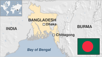
Bangladesh is a democratic country situated in the Ganges Delta. This geographic location allows the country to grow and export crops making agriculture one of the most important sources of foreign currency for the country. Dhaka, the capital, is one of the world’s largest and most heavily populated cities all over the world. Bangladesh itself is a country of more than 160 million, making it one of the most densely populated countries all over the globe.
Bangladesh is currently a part of the Next Eleven, a group of countries predicted to be economic superpowers in the coming decades. The country, indeed, is experiencing rapid economic growth at 6% annually. One of the biggest challenges the country faces is the fact that it lacks reliable energy generators. But the World Bank says that the biggest concerns are those governance-related factors.
Bangladesh was originally a part of Pakistan. However, perceived neglect and racial and religious discrimination have led to an uprising called the Bengali Independence Movement. After a bloody war, Bangladesh won its independence. Of course, the victory was not attributed to Bangladesh’ own army, but that of India’s, which dedicated its resources to support the Bangladeshi cause and beat its long-time foe, Pakistan. The independence proved to be difficult for the people, as massive famine and political instability followed. In 1991, democracy was restored, and the country started to experience economic growth, thanks in part to foreign aid.
- Agriculture 151
- Background 8
- Conflict 2
- Cost of living 53
- Crime 74
- Culture 17
- Disasters 5
- Economy 2952
- Education 553
- Energy 832
- Environment 225
- Geography 82
- Government 224
- Health 289
- Import 4
163.65 million
Population. Ranked 8th in 2013.
$747.34
GDP per capita. Ranked 156th in 2012.
130,170 sq km
Sq. km. Ranked 92nd in 2008.