
Facts and stats about Burma
Author: jaacosta47
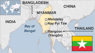
Burma is known today as the Republic of the Union of Myanmar. It is one of the members of the Association of Southeast Asian Nations or ASEAN. It is a Pariah state which has been cut off from the rest of the world and is notorious for its negative human rights record. No less than United States President Barack Obama has urged Myanmar President U Thein Sein to implement political and economic reforms for the sake of the nation.
Burma used to be under military rule for more than five decades (1962 to 2011). It repressed all types of opposition notwithstanding numerous condemnations and restrictions by the international community. The first general election was held in 2010 but was rejected by Aung San Suu Kyi who headed the major opposition party (National League for Democracy). US Secretary of State Hillary Clinton visited Myanmar in December of 2011. This was the first official visit by a top American official after 50 years. Secretary Clinton held separate meetings with President Thein and Aung San Suu Kyi. President Obama made a state visit to Burma in 2012 while President Thein was a visitor of the US Government last year.
The United States, European Union and Canada have imposed economic penalties on Myanmar but these were lifted in 2012. In fact, the EU even offered development aid worth $100 million in 2012. The economy of Burma is relatively underdeveloped. It is the biggest exporter of tropical hardwood called teak as well as a primary source of gems like pearl, jade, sapphire and ruby. Myanmar is a rural country but blessed with fertile soil and deposits of gas. However international media reports have branded the country as corrupt and mismanaged as well as controlled by the military junta.
- Agriculture 140
- Background 7
- Cost of living 53
- Crime 66
- Culture 11
- Disasters 5
- Economy 1114
- Education 388
- Energy 858
- Environment 158
- Geography 85
- Government 129
- Health 268
- Import 1
55.17 million
Population. Ranked 24th in 2013.
653,520 sq km
Sq. km. Ranked 38th in 2008.