
Facts and stats about Argentina
Author: Edsel.G
Argentina, with a land area close to three million square kilometers, is the 8th largest nation in the world. It is also among the most developed countries classified as a middle emerging economy.
Argentina is rich in biodiversity, largely due to the fact that the massive land area extends from the warm equator to the colder regions of the Arctic; thus, allowing for the existence of varied flora and fauna. The South American country is also rich in natural resources which allow it to bolster its economic growth.
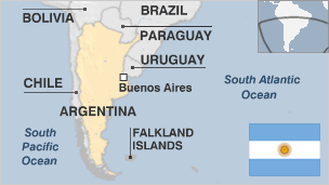
Historically, Argentina was always a highly influential country. In the first part of the 20th century, Argentina was the seventh richest in the world. However, its economic might and global affluence fell sharply later. This economic and political turmoil within Argentina forced the Argentine leaders then to invade the Falklands, hoping to get the country and its people in order again. Unfortunately, they lost the war to the British, which led to the boiling discontent of the populace which, in turn, led to the downfall of the military junta, under the leadership of General Leopoldo Galtieri.
Currently, Argentina is a member of the G-20, an organization of the world’s twenty richest countries. With a ‘very high’ Human Development Index, the South American country is set to even improve its economic status.
- Agriculture 218
- Background 13
- Conflict 2
- Cost of living 55
- Crime 83
- Culture 33
- Disasters 6
- Economy 3282
- Education 602
- Energy 1229
- Environment 226
- Geography 90
- Government 210
- Health 290
42.61 million
Population. Ranked 32nd in 2013.
$11,452.13
GDP per capita. Ranked 54th in 2012.
2.74 million sq km
Sq. km. Ranked 9th in 2008.