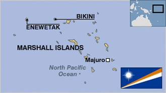
| MARSHALLESE GEOGRAPHY STATS: |
| Top Stats |
| | All Stats |
|
|
|
| |
|
|
Area > Comparative about the size of Washington, DC |
|
Capital city with population
|
Majuro - 20,000 |
|
|
|
Land use > Other
|
44.45 %
|
|
[235th of 241]
|
|
Land use > Permanent crops
|
44.44 %
|
|
[5th of 241]
|
|
Largest city
|
Majuro |
|
|
|
Largest city population
|
28,000 |
|
[162nd of 174]
|
|
Largest city with population
|
Majuro - 20,000 |
|
|
Location Oceania, two archipelagic island chains of 29 atolls, each made up of many small islets, and five single islands in the North Pacific Ocean, about one-half of the way from Hawaii to Australia |
Map references Oceania |
|
Maritime claims > Contiguous zone
|
24 nm
|
|
[17th of 82]
|
|
Maritime claims > Exclusive economic zone
|
200 nm
|
|
[63rd of 121]
|
|
Maritime claims > Territorial sea
|
12 nm
|
|
[109th of 190]
|
|
Natural hazards
|
infrequent typhoons |
|
|
Natural resources coconut products, marine products, deep seabed minerals |
|
northernmost point > Latitude
|
14°32'N |
|
|
|
Population density
|
361.32 people per sqkm |
|
[24th of 256]
|
|
Population density > people per sq. km
|
351.48 people/m²
|
...
|
[20th of 204]
|
|
Rural population density > rural population per sq. km of arable land
|
1,053.38 people/km² of arable lan |
...
|
[4th of 188]
|
|
Surface area > sq. km
|
180 km²
|
...
|
[201st of 206]
|
Terrain low coral limestone and sand islands |