
Facts and stats about United Kingdom
Author: chris.lockyer781
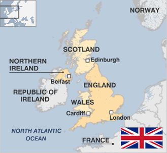
What could be called four separate countries, make up the United Kingdom. These are England, Scotland, Wales and Northern Ireland. At the beginning of the 20th century it had a large empire and was arguably the most dominant global power. By the end of the 1940s, its power was significantly reduced. However, the United Kingdom of today, is holding its own as a major player in world affairs. The United Kingdom which has one of the largest economies in the world, has been long recognized as the first country to become industrialized. Although the UK is one of the biggest players in Europe, it is not a member of the EuroZone due to differences with other member countries.
Complete devolution of powers to Scotland and Wales, has been a major topic of discussion, particularly over the last decade. Effective 1999, Northern Ireland has devolved powers with a new assembly.
The UK is a melting pot of ethnicities. This is due largely to the fact that it had colonies in different parts of the world. Lately, the nation has been been affected by issues rotating around multiculturalism, migrants and national identity.
This is against a qualifications of issues about terrorism and Islamist radicalism, increased after the destruction blast strikes on London's transportation system in 2005.
One of the latest styles in migration has been the appearance of employees from the new EU countries in Southern Europe.
The UK has a rich literacy heritage, with noted names such as William Shakespeare, Dylan Scott and Seamus Heaney.
The country is 93,638 square miles in size and has a population of close to 62.5 million.
- Agriculture 152
- Background 12
- Conflict 19
- Cost of living 55
- Crime 83
- Culture 45
- Disasters 26
- Economy 2011
- Education 408
- Energy 1739
- Environment 267
- Geography 92
- Government 224
- Health 317
63.18 million
Population. Ranked 1st in 2014.
$38,514.46
GDP per capita. Ranked 21st in 2012.
241,930 sq km
Sq. km. Ranked 76th in 2008.