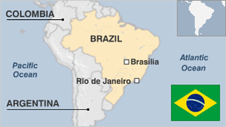
Brazil is the largest country in South America in terms of land area. Occupied by Portugal for nearly three centuries, Portuguese tradition and culture are highly observable in Brazil’s rich and varied cultural displays. The official language of Brazil is Portuguese, while native American-Indian languages (Amerindian) are spoken by a significant minority.
The economy of the country is also the largest in South America, and it is the seventh largest (by nominal GDP and purchasing power parity) in the world. Brazil has a mixed economy with a highly advanced manufacturing sector and very rich natural resources. Tourism is also an important source of profit for the government, with millions of tourists flocking in to the country annually. Foreigners visit the country to enjoy the cool climate and its popular tropical beaches which have been featured in many Hollywood films. A large number of tourists also visit Brazil to witness the huge and colorful Rio Carnival.
However, it is widely believed that corruption is siphoning billions of dollars from Brazilian coffers annually. Foreign direct investment is also affected, if not relatively discouraged, by the so-called Brazil cost – the combination of state inefficiency, corruption, economic instability, among others.
Like many developing countries, the biggest setback for the huge economic growth of Brazil is the ever-increasing disparity between rich and poor. Drug trade is also a colossal problem that the government is bent on controlling. However, the huge and complicated river and mountain systems, along with a wide coastline shared with other countries, hamper government efforts to eradicate the problem.
Posted on 06 Apr 2014
Edsel.G
247
Stat enthusiast
Brunei is a sovereign state also known as Brunei Darussalam or Abode of Peace. It is nestled in the northern coast of Borneo and bordered by Sarawak, Malaysia. It is the only sovereign state located on the island of Borneo. The rest of the island's territory is divided between Indonesia and Malaysia. It has a population of 407, 786 as of 2012.
Brunei Darussalam became a full-pledge member of the ASEAN in January of 1984 and joined the United Nation after seven months. It is also a regular member of the Asia Pacific Economic Forum, Organisation of Islamic States and the Commonwealth of Nations. Brunei maintains diplomatic missions’ worldwide and developed close relationship with Singapore as well as the Arab World.
It is a rich nation with plenty of natural resources and free healthcare services. Nevertheless, Brunei has a five percent unemployment rate even if it employs roughly 60,000 overseas workers. The country has a budget deficit of about $548 million which corresponds to 15 percent of Brunei’s Gross Domestic Product. The Royal Sultanate has been criticised for squandering Brunei’s oil wealth. The Sultan Hassanal Bolkiah lives in a lavish palace with 1,800 rooms which is bigger than that of the Vatican City.
Brunei is the most politically oppressive states among countries in the Asia Pacific. This was revealed by a monitoring group (Freedom House) based in New York. It is described by human rights groups worldwide as one of the “rogue nations”. Nearly 75 percent of the labour force works for the government. This condition has caused much discord in Brunei. The practice of non-Muslim religions is controlled and books such as the Holy Bible have been prohibited. Offspring of Brunei women married to foreign citizens are not given citizenship even if they were born in the country. Brunei has unequal power and leverage which resist pressures for change because of its massive oil fields and wealth.
Posted on 28 Mar 2014
jaacosta47
423
Stat enthusiast
Brazil has always maintained a robust economic performance among South American countries but it has trade and industry issues as well as social concerns that prevent it from securing the grade of a world power. Yet, Brazil has maintained good relations with other nations and is respected by numerous international organisations. The peace-making foreign policy of Brazil can best be described as successful application of soft power to attain national objectives. The geopolitical development does not seem to create any apprehension among the world’s super powers.
Even then, Brazil has the biggest armed forces in Latin America. It has more than 327,000 active duty military personnel. Since the county does not have to contend with any internal threats or external aggression, the Brazilian military is engaged in peacekeeping functions as a member of the United Nations. In fact, troops from Brazil have been stationed in Haiti since 2004 as the leader of the UN Stabilization Mission. The Brazilian Army has been involved in civic-action programs associated with education, health care, and infrastructure construction across the country. Meanwhile, Brazilian officials are inclined to tap the Army in reinforcing police against criminal gangs before Brazil hosts the FIFA World Cup games in 12 cities. The government will be announcing the details of the Army’s involvement and deployment within the coming weeks.
Brazil has already increased military expenditures by more than 30 percent in 2012. Strategic programs were implemented to beef up fighter and transport aircraft procurement. The defence establishment also plans to acquire submarines and update anti-aircraft gunnery capabilities. It is widely believed that increased defence spending is part of the government’s strategy to be at par with its partners in BRIC (Brazil, Russia, India and China). Brazil puts funds in military modernisation more than Colombia and ten times more than Argentina.
Posted on 28 Mar 2014
jaacosta47
423
Stat enthusiast
The educational system in Brazil is standardized by the Federal Government through the Education Ministry. It delineates policies for educational programs which serve as guidelines for local government units. However, financial subsidies are provided by the federal government. The Organisation for Economic Cooperation and Development or OECD reported that investments for the country’s education sector have gone up to a little over six percent of the GDP in 2011. This puts Brazil side by side with developed countries like Switzerland and Italy when it comes to educational spending.
However, there is a great discrepancy in terms of actual expenditures. Brazil only spends less than $3,000 for each public school student compared to Switzerland and Italy which invest $12,800 and $7,900 respectively for schools funded by the state. Brazil may have a bigger GDP but it also has a bigger populace compared to the two nations. Rich and smaller nations have more resources for education than the bigger countries.
Brazil also needs to come up with fair division of education investments across 26 states and one federal district. Even then, the largest country in Latin America falls behind regular spending rates of nations in the OECD. Brazil has been successful in sending young boys and girls to elementary school but keeping them in high school is still an issue. For instance, only 57 percent of youngsters between 15 and 17 years were able to finish the elementary level in 2010.
In 2013, the Ministry of Education spent less than one-third of the education budget for student funding although investments in education are expected to increase in 2014. Social discrimination is one of the reasons for unfairness in terms of access to education among children in Brazil. The UNESCO tries to provide financial aid to countries like Brazil in terms of access to education but the government has to do its part as well.
Posted on 28 Mar 2014
jaacosta47
423
Stat enthusiast
In response to - <p><i>Roberto</i> - Try this news site: http://www.brazilink.org/politics.asp <p><i>Gene</i> - Alan Foum created this <a href=http://freespace.virgin.net/alan.foum/>site</a> that provides a directory and links to several sites on the oil & gas industry, many of these with country-specific info.
Posted on 24 May 2005
Suchita Vemuri, Staff Editor
Brazil has a bicameral governing body made up of the Federal Senate (Upper Chamber) and Lower Chamber of Deputies. The nation’s president is elected to a four-year term. He or she is eligible to serve for one more tenure. There are 81 senators who are elected for eight years while the 513 deputies are elected for only four years. The country is divided into 26 states and one federal district (Brasília) with each state having a governor and legislature.
Brazil has always been acknowledged as one of the leaders in the inter-American community. The nation played a vital role in combined security initiatives and economic collaboration in the Western Hemisphere. It belongs to the Organization of American States and part of the Inter-American Treaty of Reciprocal Assistance (Rio Treaty). Brazil has focused on expanding relationships with its South American neighbors. In fact, it is a founding member of the Latin American Integration Association and the Union of South American Nations composed of Brazil, Argentina, Uruguay, Paraguay, Chile, Bolivia, Peru, Colombia, and Ecuador.
Posted on 28 Mar 2014
jaacosta47
423
Stat enthusiast
Hi Piper, see: http://www.nationmaster.com/country/br/Economy and also follow the links from that page, especialy the section under 'Encyclopedia'.
Posted on 21 Feb 2005
Suchita Vemuri, Staff Editor
There is info on all of those things. You just need to look for it.
Where can I find info on Brazil,Please
me.................................
In response to Albert P Revilles -- one of the best sources of the kind of detailed information you\'re looking for, would be http://www.worldbank.org/, where you could do a search for \"VAT+Brazil\". You could also try to <a href=http://web.worldbank.org/WBSITE/EXTERNAL/EXTABOUTUS/0,,contentMDK:20041066~menuPK:34582~pagePK:43912~piPK:44037~theSitePK:29708,00.html>contact </a> The World Bank people; they\'re generally very helpful.
Posted on 22 Mar 2005
Suchita Vemuri, Staff Editor